|
MapCatalog | Order | Support | SiteIndex | Contact | Home | ||||||||||
|
|
|
|
|
|
|
|||||||||||
| Africa | 105 | |||||||||||||||

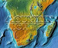
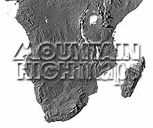
Mountain High Maps Catalog - Southern half of continent
Map Specifications for Southern half of continent
| Map identification: | 105 | Projection system: | Lambert's equal-area |
| Map coverage: | Southern half of continent | North boundary: | 05° 00' N |
| Image size (pixels): | 2,382 x 1,983 pixels | South boundary: | 35° 00' S |
| Image size (inches): | 7.94 x 6.61 inches | East boundary: | 55° 00' E |
| Image size (metric): | 202 x 168 millimeters | West boundary: | 05° 00' E |
| Resolution per pixel: | 2,200 meters | Horizontal scale: | 1:10,000,000 |
| RGB file size: | 13.5 Mb | Vertical scale: | 1:410,416 |
| CMYK file size: | 18.1 Mb | Vertical interval: | 125 meters |
| Grayscale file size: | 4.5 Mb | Vertical exaggeration: | 24.4 times normal |
|
Countries, states and territories: |
Angola, Botswana, Burundi, Cameroon, Comoros, Congo, Equatorial, Guinea, Gabon, Kenya, Lesotho, Madagascar, Malawi, Mayotte, Mozambique, Namibia, Rwanda, Sao Tome & Principe, Somalia, South Africa, Swaziland, Tanzania, Uganda, Zaire, Zambia, Zimbabwe, |
||

|
| ||
|

| ||
|
Top left: Elevation low-contrast relief rendering Top right: Vegetation high-contrast relief rendering Middle left: Grayscale land-only relief rendering Middle right: Political low-contrast relief rendering Lower right: Geo-political Illustrator EPS vector maps Inventory of maps and masks within each map portfolio
|
 |

| Southern Africa Map #105 - Buying Options |
|
|
Vector only EPS map available for immediate download Complete Southern Africa Relief and Vector Map Package for download |
|
© Digital Wisdom, Inc.