|
MapCatalog | Order | Support | SiteIndex | Contact | Home | ||||||||||
|
|
|
|
|
|
|
|||||||||||
| N.America | 210 | |||||||||||||||

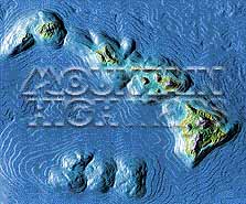
Mountain High Maps Catalog - Hawaiian Islands
Map Specifications for Hawaiian Islands
| Map identification: | 210 | Projection system: | Conic projection |
| Map coverage: | Hawaiian Islands | North boundary: | 23° 00' N |
| Image size (pixels): | 2,101 x 1,747 pixels | South boundary: | 18° 00' N |
| Image size (inches): | 7.00 x 5.82 inches | East boundary: | 154° 00' W |
| Image size (metric): | 178 x 148 millimeters | West boundary: | 161° 00' W |
| Resolution per pixel: | 300 meters | Horizontal scale: | 1:2,000,000 |
| RGB file size: | 10.5 Mb | Vertical scale: | 1:500,000 |
| CMYK file size: | 14.0 Mb | Vertical interval: | 152 meters |
| Grayscale file size: | 3.5 Mb | Vertical exaggeration: | 4.0 times normal |
|
Countries, states and territories: |
Hawaii, Kahoolawe, Kauai, Lanai, Maui, Molokai, Nihau, Oahu, |
||

|
| ||

|

| ||
|
Top left: Elevation low-contrast relief rendering Top right: Vegetation high-contrast relief rendering Middle left: Grayscale land-only relief rendering Middle right: Political low-contrast relief rendering Lower right: Geo-political Illustrator EPS vector maps Inventory of maps and masks within each map portfolio
|
 |

| Hawaiian Islands Map #210 - Buying Options |
|
|
Vector only EPS map available for immediate download Complete Hawaiian Islands Relief and Vector Map Package for download |
|
| Special Hawaiian Islands |
| Complete Hawaiian Islands Relief Map Portfolio Includes Hawaii, Oahu, Kauai & Nihauu, Maui, Molokai, Lanai & Kahoolawe |
© Digital Wisdom, Inc.